featured item

folding map city london, westminister & southwark 1671

antiques available from other sellers in antiques interior design modern and vintage > other interior design
-
![Portrait of ADC to Mountbatten of Burma]() £1500
£1500portrait of adc to mountbatten of burma Read more
Artware Ltd -
![JOHN DAY AMERICAN BORN 1932 DIED 1982 Exhibited at 25 Grand-Rue Vieille Ville 1204 Geneva Switzerland see further details WWW.ARTADVISOR.CH]() £16000
£16000john day american born 1932 died 1982 exhibited at 25 gra... Read more
John Day Estate -
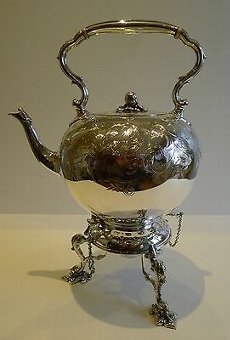
![Grand Antique English Silver Plate Spirit Kettle c.1880]() £901.34
£901.34grand antique english silver plate spirit kettle c.1880 Read more
Puckering's -
![A chic 1950s Italian oval segmented mirror]() £1250
£1250a chic 1950s italian oval segmented mirror Read more
Seveteen-Twentyone


- View other items in:
- antiques interior design modern and vintage
- other interior design
Still not found something similar? Why not save a search and get a notification in your inbox when an matching antique is added to our ever-growing database?
Enter your email address to be sent alerts when new items are added to the site that match your search criteria

This is a folding map of London, Westminister, & Southwark which was first published in 1691. It is certain to be a talking point in your home, or wherever you choose to display it.Folding maps were practical items for use on the open road in ancient times. With the development of the roads and canals in Britain people relied on improved surveying techniques that in turn this led to more accurate maps. The size and the rapid expansion of London and other cities meant that good maps were essential to anyone wishing to travel around the city and beyond without getting lost.As the number of travellers grew so did the demand for maps, which had to be large enough to read but small enough to carry around. They had to be robust, a purely paper map would soon disintegrate with constant opening and closing. The solution was to dissect the map and lay it down on linen or calico, which greatly extended the map''s life.The map is very detailed, and shows a plan of the Londonk at street name level as it was in the 1690s. MeasurementsThe map measures 53 cm high and 139 cm wide.ConditionThis map is in excellent condition. Please see photos for confirmation of its condition.
Antiques.co.uk Ref: QNHJD934
Here on antiques co uk we love antiques and specialise in selling antiques. Even though this item was for sale and is now sold or otherwise now unavailable we have many more items for sale including vintage antiques, silver, tables, watches, jewellery and much more for your interiors and home.
Search all the antiques currently for sale on www.antiques co uk. Or why not consider selling your antiques and making sales more easily with us!