


featured item

Naval navigation
Posted by Gillian Jones on 14/02/2016
In this post we’re going to take a look at how naval navigation started before modern methods – and it’s fascinating. You’ll find that simple methods moved on to more sophisticated ones with the advancement of science, and the genius of one or two individuals both here and overseas.
How did the old mariners find their way around undiscovered waters?
In the beginning celestial navigation would have helped sailors find their way around the oceans. By measuring the altitude of the Northern Star above the horizon, the angle in degrees helped measure the latitude of the ship.
However, more sophisticated forms of navigation were developing
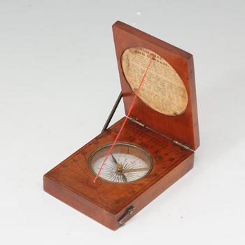
The Mariner’s compass is one of the earliest man made navigation tools. It could be hit and miss for sailors as they found it difficult to understand. Magnetic variation meant that often, the readings were inconsistent. The compass was used mostly when the sun was down and to help sailors to see which direction the wind was blowing.
From around the 13th century nautical charts or maps proved extremely useful in navigating a ship, it took time for them to become more sophisticated and naturally, they weren’t particularly accurate until much later. There was no latitude or longitude, but a compass rose between each port gave directions on which way to travel.
The Astrolabe, sextant and chip log did much for sailing and navigation. The astrolabe has its roots in ancient Greece and at one time helped astronomers tell the time.
The sextant, was invented by two different people namely, John Hadley the English mathematician and Thomas Godfrey, an American. This was at last a really accurate way of discovering the angle between the horizon, stars, sun and the moon.
The chip log was the very first type of speedometer, it consisted of a line with knots which were at regular intervals, and was weighted so that it would drag in the water once it was thrown over the stern of the ship. By counting the number of knots they were able to calculate the ships speed.
Longitude was an estimate only up until when the chronometer was came along and changed everything. It was invented by John Harrison (1693 – 1776) and it would revolutionise naval navigation. In 1779 Captain Cook used it to circumnavigate the world, and following his journey the longitudinal calculations made using the chronometer were accurate.
So there you have it – some of the best naval navigation tools used in the past when the world was being discovered for the first time. Naturally, naval navigations have gone though many changes over the years and the methods used to measure distance, location and speed today are much more sophisticated.
Keep an eye out for anything nautical on www.antiques.co.uk and see if you can find yourself a naval navigation tool to add to an already existing collection or a new one if you’re about to start. You’ll find naval navigation tools under ‘nautical antiques’ on the left hand side of the home page, and save your search for our email notifcations. Good luck!