


antique maps and cartography
Antique maps Cartography and Travel. Aventure who discovered the world. See our antique world maps and antique globes.
-
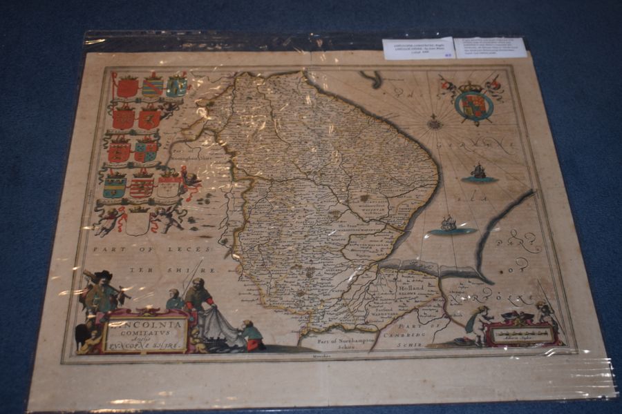
Lincoln Comitatus. Anglis Lincoln-Shire. by Joan Blaeu
lansdowne antiques, dorking, united kingdom
Lincoln Comitatus. Anglis Lincoln-Shire. by Joan Blaeu 1648. A very attractive and finely engraved 17th century map of Lincolnshire which was published in Joan Blaeu's Toonneel des Aerdrycks, oft Nieuwe Atlas or Vierde Stuck Der...
£425.00
view details -
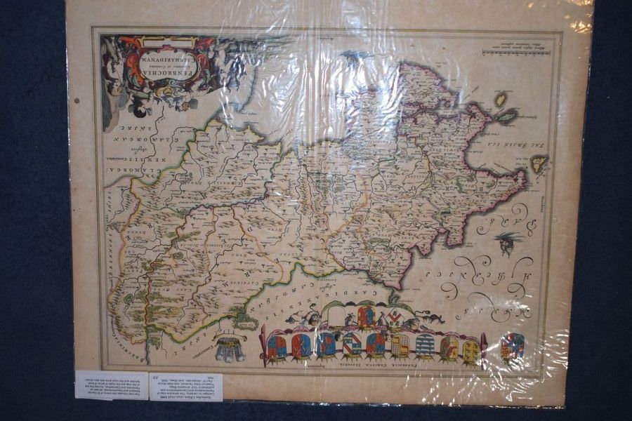
Penbochia J. Blaeu 1645-1648. Cardigan to Llanethly
lansdowne antiques, dorking, united kingdom
Penbochia J. Blaeu 1645-1648. Cardigan to Llanethly. This attractive map of Pembrokeshire and Carmarthenshire was published in "Guil. et Ioannis Blaeu Theatrum Orbis Terrarum, sive Atlas Novus - Part IV", Amsterdam, Joan Blaeu, 1645, 1646....
£450.00
view details -
Deed of sale. Watercolor plan of the land of 1912.
sia antion, riga, latvia
Deed of sale. Land plan of the Smiltene castle in Jaunciems from 1912. Print, ink, watercolor. Paper on canvas. Width: 44cm, Height: 46cm, Depth: 0.02cm, Weight: 0.2kg, Condition: As is, Material: Mixed media, ID: 4794
£212.84
view details -
Frederick DeWitt Map of Russia. 1680 g.
sia antion, riga, latvia
Frederick DeWitt. Map of Russia. 1680 g. Unframed size: 44 x 56 cm. Width: 76cm, Height: 66cm, Depth: 3cm, Weight: 2kg, Condition: Good, Material: Engraving, ID: 4710
£638.52
view details -
Map of Russia at the end of the 17th century.
sia antion, riga, latvia
Map of Russia at the end of the 17th century. JAILLOT, HUBERT, Nova Russiae albae sive Moscoviae ... La Russie Blanche ou Moscovie. Amsterdam (Mortier) late 17th century. Colored engraved map. Dimensions of the card: 50x60 cm. Width: 103cm, Height: 72cm, Depth: 2cm, Weight: 1kg, Condition: Good, with traces of use, Material: Engraving, ID: 5669
£383.11
view details -
Fisher’s Ground Plan Of The Royal Palace Of Whitehall
vintage midcentury, seaford, united kingdom
Rare a reduced coloured copy of Fisher’s ground plan of the Royal Palace of Whitehall This plan of the Royal Palace was published in the early 19th century but is actually a copy of a...
£225.00
view details -
#10173 Sifton Praed Full Set of 37 Bartholomew 1930’s Motoring Maps of England & Wales
gerald mathias fine antique boxes, chiswick, united kingdom
SEFTON PRAED & CO. LTD THE MAP HOUSE 87 ST JAMES STREET LONDON SW1 Publishers, Map Sellers , Geographical and Military Booksellers By Appointment to His Royal Highness the Prince of Wales Offered in excellent,...
£995.00
view details -
G. Schreiber. Map of Courland and Livonia, 1730s.
sia antion, riga, latvia
G. Schreiber. Colorized map of Courland and Livonia. Leipzig 1730s. 19x26.6 cm. Width: 35.5cm, Height: 26cm, Depth: 0.5cm, Weight: 0.173kg, Condition: Good, Material: Paper, ID: 6106
£306.49
view details -
Plan of Narva and Ivangorod during the Northern War. Charles XII.
sia antion, riga, latvia
Plan of Narva and Ivangorod during the Northern War. Charles XII. 17x25 cm. Width: 32cm, Height: 26cm, Depth: 0.5cm, Weight: 0.150kg, Condition: Good, Material: Paper, ID: 6105
£315.00
view details -
Map of Russia at the end of the 17th century.
sia antion, riga, latvia
Map of Russia at the end of the 17th century. JAILLOT, HUBERT, Nova Russiae albae sive Moscoviae ... La Russie Blanche ou Moscovie. Amsterdam (Mortier) late 17th century. Colored engraved map. Dimensions of the card: 50x60 cm. Width: 103cm, Height: 72cm, Depth: 2cm, Weight: 1kg, Condition: Good, with traces of use, Material: Engraving, ID: 5669
£383.11
view details -
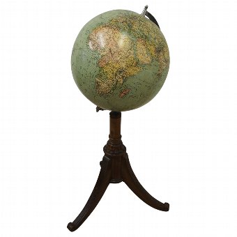
Globe on Stand
georgian antiques, edinburgh, united kingdom
Circa 1900, globe on stand. With globe in excellent condition, it is on a turned column with flared circular section that features foliate casting, tripod base and legs. It finished on a curling, cabriole leg....
£1,250.00
view details