


Maps and movement
Posted by Amy Lugten on 15/08/2014
Peoples of the past moved about their land in different ways, and this influenced the way they interacted. It is also very important for looking at how the maps they made symbolized how they identified with their local area. Often maps of previous centuries show villages that are now non-existent, or curiosities such as landmarks and waypoints that are rather humorous.
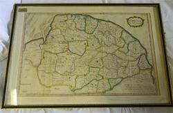
Robert Morden was one of the most original and best mapmakers of the seventeenth century, and an example of one of his maps is for sale on the website here. Morden was more than just a mapmaker – he made a significant contribution to the knowledge of the English and Welsh countrysides. His maps would be reissued again and again over the subsequent decades.
Morden made public the knowledge of farther shores. His firm published maps of North America and (what was) Ceylon, among other places. Morden’s work was heavily published in Camden’s Britannia, a collection of maps and cartography relating to the British Isles. What we find in Morden’s maps is a very great attention to simplification and clarity. What may look hard to read to our eyes was in fact a vast advancement on earlier maps of the time.
Morden’s maps also usually featured an intricate yet beautifully designed cartouche in the top right of the map, and an accurate and helpful scale in the bottom right corner. Morden was making advancements on earlier efforts at sophisticated mapping by such men as John Speed and the Dutchman Willem Blaeu. To emphasise the advancements map in mapmaking by the time of Morden, one need only look at early efforts by Christopher Saxton to see the technical evolution of maps.
Finally, and very importantly, antique maps have become something in the order of artworks themselves. They are often hand-coloured, arrayed with lovely reds, yellows and greens, and featuring fine cartouches and scales. Some have also survived the degradation of the ages and fought off the acidic attacks on the paper and ink. If you can find these, you are onto a winner.